LRPS-1
Tactical Mapping Drone (long range)
LPRS-1 a Cyber-Secure Governmental and Tactical Mapping Drone
Wingspan: 3000mm
MTOW: 3500g
Operation radius: approx. 50km
Visual navigation
Cruise speed: 10-15m/s
Noise level: less than 30dB at 100m
Thermal camera: 640x512 pixel / 25mK
High performance on board computing
Observation altitude: 100 – 400m
Max flight time: 3,5h
In flight data processing (optional)
One or two directional digital data link (optional)
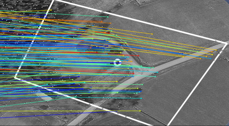
Visual Navigation System (VNS)
Overview of Visual Navigation System (VNS)
Independent navigation in areas with high radio interference
Operates without reliance on GPS or other radio data links
Data and Inputs
Requires only basic input like actual orthophotos or map tiles (e.g., Google Maps Satellite Images)
Initial requirement of a home point to efficiently start the matching process
AI-Driven Position Matching
Utilizes AI to match its own position with map input data
Delivers position accuracy better than 15 meters
Provides position updates every second, ensuring continuous navigation.
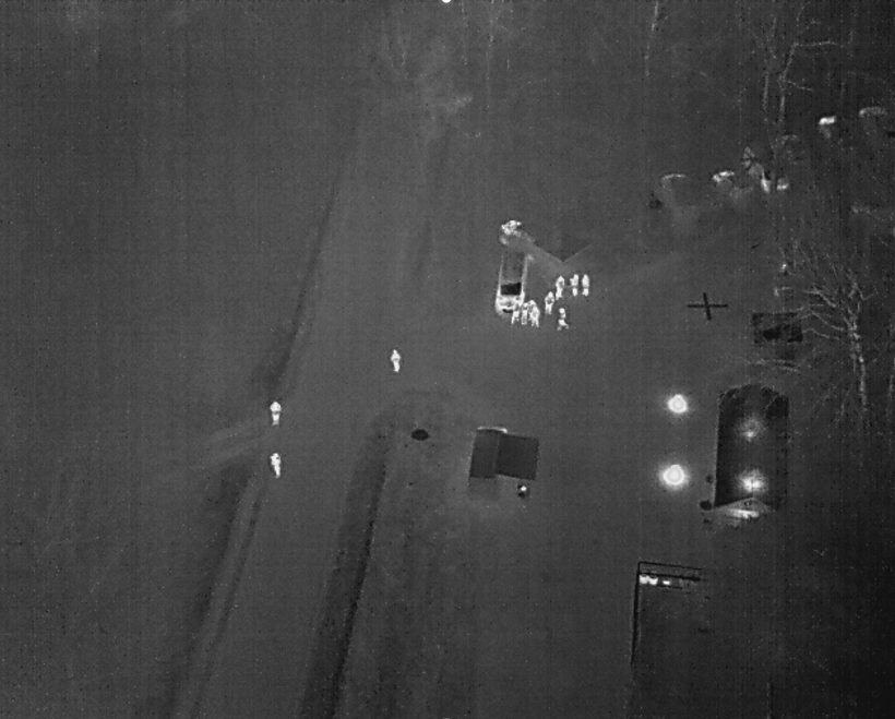
Thermal Imaging

Dual-Camera System
Equipped with a thermal camera and an RGB camera without NIR filter for low-light capabilities
Functional during nighttime using thermal images
Enhanced Navigation Capabilities
Calculates precise flight direction and altitude
Robust system design suitable for diverse operational environments
Limitations
Does not operate effectively in foggy conditions
Ineffective over open sea environments
Performance issues when there are significant deviations from base map materials

Reconnaissance Mapping
High-Resolution Thermal Imaging
Optional 35mm thermal camera designed for high-resolution thermal mapping tasks
Enables detailed and precise thermal data capture, crucial for accurate terrain and object analysis
Advanced Gimbal Mechanism
Equipped with a gimbal that actively tilts from right to left to effectively expand the reconnaissance area
Focuses on enhancing coverage area rather than stabilizing the image, optimizing mapping efficiency
Strategic Benefits
Expands the scope of surveillance and mapping over larger areas with a single pass
Critical for missions requiring extensive area assessment and detailed environmental data
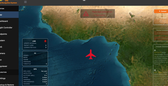
BEAST TX
System to handle data link connections
Enables safe return during unforeseen events
Provides mission data delivery and FPV control interface
BeastTX Technical Specifications:
Intel Quad Core 3.0 GHz processor
8 GB RAM, 256 GB SSD (expandable on request)
1275cd display brightness
6 hours of operation time
More details at: www.beasttx.com
